The end of summer would be sad if it weren’t for the arrival of autumn in Virginia. It is that time of year when the green forests of the Appalachians, Piedmont and Coastal Plain turn to vibrant reds, glowing yellows, fiery oranges and deep maroons, all contrasting against a crystalline blue sky. It is time to get out and see fall’s kaleidoscope of color, to smell the drying leaves and take in that crisp air.
It is time to go on a fall foliage hike in Virginia.
Fall color chasers want certain elements in their hike this time of year: variety of color, places to see the color both up close and in the distance. We want to hike through a colorful forest, to be in the mix, yet be able to look upon other distant woodlands where reds, yellows and oranges create a contrasting palette that will astound you.
Here are 10 Virginia fall foliage hikes that will leave you reaching for your camera or phone time and time again, to capture another moment of autumn splendor.
Below, you will see the hike, the nearest town to where the hike is located, the fall color peak time, an essential fact about the hike, then the GPS coordinates of the trailhead. With this information, you can head out and create your own fall foliage experience in Virginia.
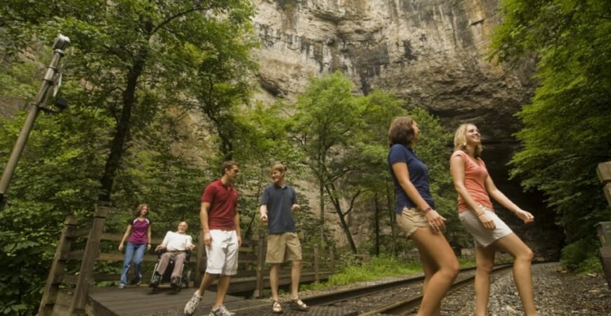
NATURAL TUNNEL PARK
- Nearest Town: Weber City
- Hike Distance: 1.8-mile loop including a side trip
- Fall Color Peak: Late October to November 1
- What You Need to Know: Don’t miss the side trip to the historic Carter Cabin.
- GPS Coordinates: 36.70219, -82.74565
This is one of those hikes so full of must-visit highlights that it is hard to get a head of steam going. For starters, you hike down to the Natural Tunnel. Well, you actually don’t have to hike down there, since a park sky lift can take you down to Stock Creek and the Natural Tunnel for a fee. More importantly, it will take you back up again.
Even if you use the skylift, you will still hike to other features. Visit the highs and lows of Virginia’s famed Natural Tunnel, woods along Stock Creek, and more distant panoramas from Lovers Leap. First, leave the visitor center, then head down into a rock amphitheater to view the cave-like tunnel entrance, then trek along Stock Creek to see the 220-year-old Carter Cabin. Generations of the Carter Family dwelt in this log structure, just a few hollows over in Rye Valley. It was reconstructed here in the park, and makes an excellent fall color backdrop. After that, climb from the Stock Creek gorge then walk along its rim, gaining rewarding views, culminating with a trip to Lovers Leap, where autumn’s glory reigns.
LEESYLVANIA STATE PARK
- Nearest Town: Dumfries
- Hike Distance: 2 miles of trails
- Fall Color Peak: End of October through early to mid-November
- What You Need to Know: View from Freestone Point will reflect autumn color off Occoquan Bay and the Potomac River
- GPS Coordinates: 38.5896, -77.25632
This hike travels hills above the tidal Potomac River. From the trailhead leave the scenic shore — ideal for a picnic — to climb to Freestone Point, the site of a Confederate battery erected in September of 1861, with three cannons and a commanding view of Occoquan Bay and the Potomac River and Maryland beyond. The cannons are gone but the majestic panorama remains, a fine fall foliage vantage. From there, visit the site of Fairfax, a home from the early 1800s. More woodland winding give you up close fall color on the way to the historic Lee homesite, Leesylvania, dating back to before the United States was a country. Pass the Lee home garden and cemetery amid more hilly mature forest, then return to the riverside picnic area.
THE PRIEST WILDERNESS
- Nearest Town: Steeles Tavern
- Hike Distance: 3.6-mile there-and-back
- Fall Color Peak: Mid-October through November 1
- What You Need to Know: Bag two hikes from one parking spot. This is also the upper trailhead for legendary Crabtree Falls.
- GPS Coordinates: 38.11585, -77.81854
Even if you don’t take two hikes from this trailhead, and only hike to The Priest, you will be well rewarded. The hike to The Priest travels through The Priest Wilderness, a 5,963-acre reserve set aside in the year 2000. The wilderness encompasses the highest part of The Priest Mountain, as well as springs and streams spilling off it. The reason for the peak’s name has been lost to time. The trek starts at Crabtree Meadows. Follow a rough jeep track (don’t try this in your vehicle) up a half-mile to the Appalachian Trail, where you join the AT then pass a trail shelter before coming to The Priest Overlook, a fine spot to enjoy nature’s autumn palette.
The view is a panorama of autumn splashed mountains, a wilderness landscape devoid of civilization’s signs. Below, the Tye River gathers its tributaries, including Crabtree Creek. From the left, the color-framed outcrops of Pinnacle Ridge stand out. Beyond, the Big Levels on the Blue Ridge Parkway, then Torry Ridge, then the Devils Knob and Three Ridges Wilderness form a left-to-right frame. On a clear day, Massanutten Mountain can be seen in the most remaining distance.
TINKER CLIFFS
- Nearest Town: Daleville
- Hike Distance: 3.6-mile there-and-back
- Fall Color Peak: Mid-October through November 1
- What You Need to Know: The Tinker Cliffs stretch for a considerable distance, explore their entire length.
- GPS Coordinates: 37.45762, -80.01742
Tinker Cliffs features some of the finest panoramas in Western Virginia, perfect for a fall trek. And the hike – with a 1,500-foot climb — has other rewards, too, such as two streams and views of Tinker Cliffs en route. A well-constructed trail with multiple switchbacks eases the ascent to one of the Roanoke valley’s iconic destinations.
The route to the fabulous Tinker Cliffs uses the Andy Layne Trail, named for an outdoors enthusiast of the first degree. Enjoy view up to the cliffs as you cross the open meadows of Catawba Creek, along with fall wildflowers such as aster. Climb away from Catawba Creek to meet the Appalachian Trail. Curve around to the west side of Tinker Mountain. The views get better as the AT runs along the edge of open outcrops. They beckon you outward to first rate views. Mountains and valleys open to the west of the Catawba Valley and waves of mountains, then southwest even to McAfee Knob and a cavalcade of autumn’s colorations.
ROBERTSON MOUNTAIN
- Nearest Town: Luray
- Hike Distance: 6.8-mile there-and-back
- Fall Color Peak: Mid-October through late October
- What You Need to Know: Views go a long way from this lesser-visited outcrop at Shenandoah National Park
- GPS Coordinates: 38.57997, -78.38116
Robertson Mountain is one of Shenandoah National Park’s better, but least visited, scenic summits, ideal for a fall hike away from the crowds. Reaching the rocky summit is neither difficult nor time-consuming, but most people pass it by to climb nearby Old Rag, one of the park’s busiest destinations, or other nearby summits like Stony Man and Hawksbill.
First, you will leave Skyline Drive and explore a highland cove and wetland, on the all-access Limberlost Trail. You will then join Old Rag Fire Road, where the walking is easy, allowing you to enjoy the shades of autumn along the way. A more traditional singletrack foot trail takes you the last mile to the outcrops of Robertson Mountain. There, various rocky points avail sweeping views in three directions. The depths of Whiteoak Canyon fall below. The hump of Hawksbill Mountain looms tall to the southwest. Old Rag stands to the east. Interestingly, Robertson Mountain — at 3,296 feet — is five feet higher than Old Rag. Soak it all in. It’s great being on top of this mountain.
ROCK CASTLE GORGE
- Nearest Town: Floyd
- Hike Distance: From 1 to 10.7 miles
- Fall Color Peak: Mid-October through early November
- What You Need to Know: You can do the whole loop or hike just the high country section for a shorter there-and-back
- GPS Coordinates: 38.57997, -78.38116
You can make a great 3.2 mile there-and-back walk from Saddle Overlook on the Blue Ridge Parkway on the Rock Castle Gorge Trail. Head south, then split toward toward Rocky Knob. Soon reach a former Appalachian Trail shelter, standing on the precipice of Rocky Knob, overlooking the gorge below. Easterly panoramas extend beyond the gorge onward through the Piedmont, where fall color will be in the highlands around Rocky Knob or the lowlands below. This creates for a failsafe option – either high or low there will be color.
Keep south on the knife-edge of Rocky Knob, passing Rocky Knob Picnic Area. Ahead, walk the gorge edge. The drop off below is a doozer. Emerge at the Rock Castle Gorge Overlook and the parkway. Ahead, a spur goes right to the Rocky Knob visitor center. Keep straight and shortly emerge at the Twelve O’ Clock Knob Overlook, a good place to backtrack after 1.6 miles. I must add that the whole 10.7 mile Rock Castle Gorge Loop is a Virginia classic hike any season of the year.
HENRY LANUM TRAIL
- Nearest Town: Amherst
- Hike Distance: 6.4-mile loop with spurs up to Mount Pleasant
- Fall Color Peak: Mid-October through early November
- What You Need to Know: The twin lookouts atop 4,021 Mount Pleasant are worth the side trip
- GPS Coordinates: 37.75918, -79.18974
This spot truly lives up to its name. Mount Pleasant National Scenic Area contains a wealth of views from both meadows and mountaintops. This trek within the George Washington National Forest uses the Henry Lanum Trail to cruise to the top of Mount Pleasant with twin outcrops that deliver a 1-2 panorama punch, delivering a fall color knockout. Be apprised nice weather weekends can be busy.
The Henry Lanum Trail first crosses the headwaters of North Fork Buffalo River then climbs to a wide gap below Mount Pleasant at 7.9 miles. A spur switchbacks up Mount Pleasant then splits to east and west overlooks where mountains, meadows and valleys widen to the west and the Piedmont extends to the eastern horizon.
After descending Mount Pleasant you roll to Mount Pompey, an outcrop and northeasterly view. More ridge running returns you to the parking area, finishing the circuit.
BULL RUN MOUNTAINS CONSERVANCY
- Nearest Town: Leesburg
- Hike Distance: 4.7-mile loop
- Fall Color Peak: Late October through early November
- What You Need to Know: Thoroughfare Gap, where this hike takes place, has been a travel corridor since people stepped foot on this continent.
- GPS Coordinates: 38.82461, -77.70574
Hike to an overlook with a grandstand view of the Blue Ridge Mountains. The Bull Run Mountains Conservancy manages 800 acres of the greater 2,486-acre Bull Run Mountains Natural Area Preserve, where fall color will be seen near at hand as well as looking toward the Blue Ridge. Start at the south end of the Bull Run Mountains, first passing ruins of a tavern, then coming to huge Chapmans Mill, once a thriving operation. From there, walk through oaks, pines and rocks aplenty atop the ridgeline. Leave Conservancy property using an easement to access a large rock outcrop framed with Table Mountain pines, presenting a colorful panorama toward points west, where the Blue Ridge rises in all its glory. Finally, backtrack to pass a hand-dug linear quarry and a family cemetery, mixing autumn splendor with Virginia history.
GRASSY HILL NATURAL AREA PRESERVE
- Nearest Town: Rocky Mount
- Hike Distance: 6.5 mile balloon loop; can be made shorter
- Fall Color Peak: End of October through early November
- What You Need to Know: An abundance of hickories and oaks add fall color.
- GPS Coordinates: 37.01521, -79.8937
Take this ridge hike above the town of Rocky Mount. This preserved parcel of the Virginia natural heritage program offers a pair of loops that run atop Grassy Hill, wooded in rich forests of oak and hickory. Three overlooks provide views of Rocky Mount and the Piedmont below. Hikers can easily alter their Grassy Hill trek, doing the full 6.5-mile circuit, or cut the loop in half, or execute a there and back hike to the East Loop overlook – the reserve’s finest, where autumn extends east across Rocky Mount and beyond, deep into the Piedmont.
The trailside hardwood habitat was worth preserving. In the late 1990s, the 1,295-acre preserve was added to the Virginia natural heritage program. However, it is the views that attract many hikers. They are stretched out along the three mile ridge that forms Grassy Hill. Don’t ignore the yellow hickories and the varied oaks along the trail while hiking toward those views.
LAKE ANNA STATE PARK
- Nearest Town: Fredericksburg
- Hike Distance: 4.5-mile loop
- Fall Color Peak: End of October through early-to-mid November
- What You Need to Know: Lake Anna was impounded in 1971, and is now one of Virginia’s most popular recreation lakes.
- GPS Coordinates: 38.11585, -77.81854
This woodland ramble with lake and shoreline views is situated along the shores of 2,000 acre Lake Anna State Park. Start at the main park trailhead, then make a loop using the Sawtooth Trail to join the Glenora Trail, wandering through what once was known as the Big Woods, ideal for fall color. Emerge at Glenora Plantation site, then grab some views of bright leaves reflecting off the lake. Join the Big Woods Trail, spurring off to see an old homesite. The Turkey Run Trail takes you back inland, enjoying more intimate forest color, before returning to the trailhead.
Written by Johnny Molloy for Virginia is for Lovers and legally licensed through the Matcha publisher network. Please direct all licensing questions to legal@getmatcha.com.